
Maxus Mining Reports on Exploration Insights at the Lotto Project in British Columbia
VANCOUVER, British Columbia, Oct. 27, 2025 (GLOBE NEWSWIRE) -- “Maxus” or the “Company”) (CSE: MAXM | FRA: R7V), is pleased to provide a summary of exploration highlights at its 3,054-hectare Lotto Project (“Lotto” or the “Project”) in British Columbia (Please see Figure 1). The Company has completed a comprehensive review of more than fifteen (15) historic assessment reports outlining several historic critical mineral occurrences and prospective polymetallic exploration targets for tungsten and other critical metals.
Key Highlights:
- High-grade Tungsten mineralization: Historical samples containing visible scheelite mineralization at the Loto 3 showing returned assays up to 10.97% WO3.1
- Polymetallic Potential: Historical geochemical soil sampling identified anomalous zones of Mo, Cu, Ag, Zn, and W in the Midas showing area, associated with key structural controls.
- Prime Jurisdiction & Location: Lotto is road accessible, strategically located along the Crowsnest highway in the Trail Creek Mining District less than 20 kilometres away from Castlegar, BC.
Scott Walters, Chief Executive Officer of the Company, commented, “The historical results at the Lotto Property provide a compelling indication of the strong discovery potential we see across the Project. With encouraging molybdenum, silver, and copper values in the Midas area alongside occurrences of high-grade tungsten at the Loto 3 Area, the Project offers exposure to both traditional and critical minerals. These results reinforce our confidence that Lotto can deliver meaningful value as we unlock its multi-metal potential through modern exploration.”
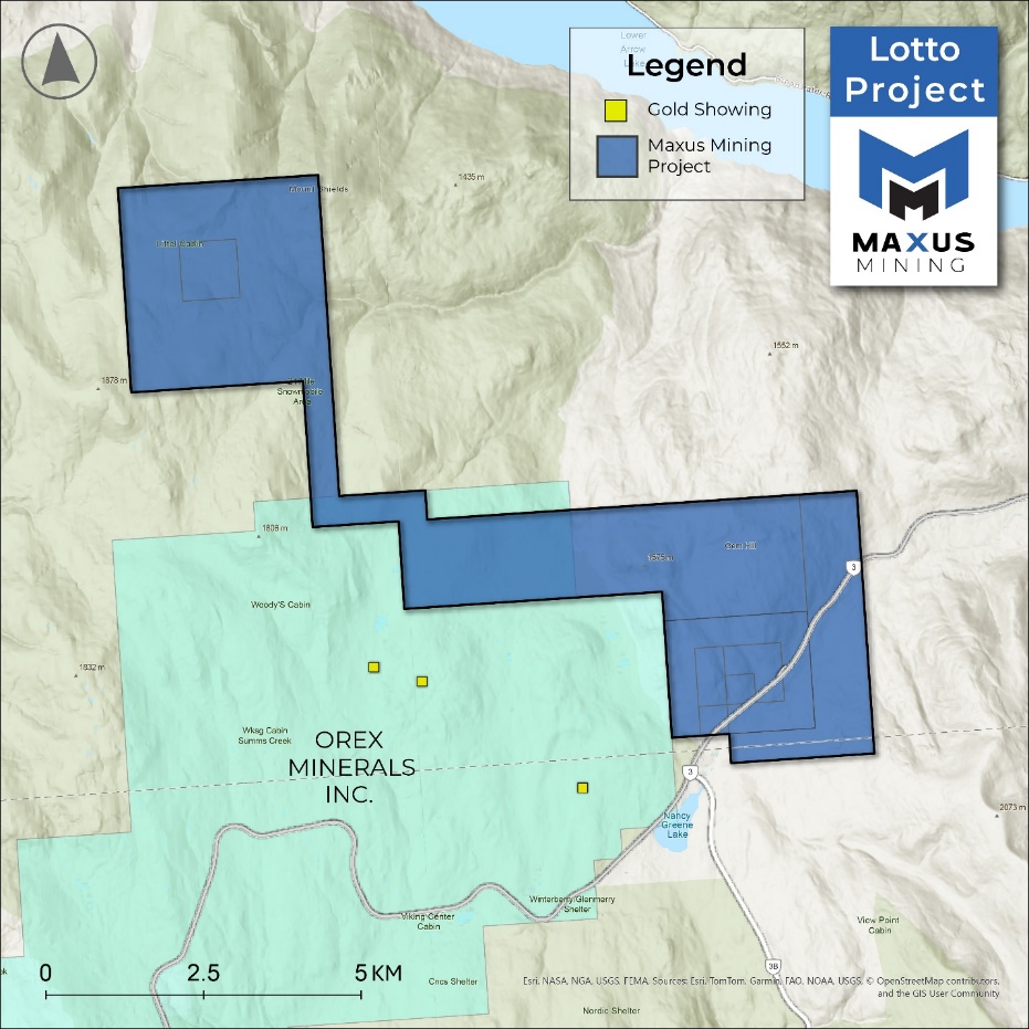
Figure 1: Lotto Project Map
About the Lotto Project
The Project is comprised of 3,054-hectares of critical mineral exploration ground in the Kootenay region and Trail Creek Mining Division of British Columbia, a prolific mineral district with excellent infrastructure supporting ongoing exploration and development. The Project lies 19 kilometres west-southwest of Castlegar, accessible directly from the Crowsnest Highway.
Geologically, the Project is underlain by rocks of the Coryell Plutonic Suite, with prominent east-west trending breccia zones crosscutting the intrusive package. Younger quartz and quartz-magnetite vein stockworks overprint the country rocks and older breccias and are particularly developed along the margins of the breccia structures. The structural complexity of the area provides ideal conduits and controls on mineralization. Molybdenite mineralization has been reported within and along the edges of breccia zones, as well as within shear zones associated with chlorite-magnetite alteration.1
The Project hosts two historical showings of note. The Loto 3 showing, located in the southeast portion of the Project, consists of scheelite (Ca(WO4)) mineralization within a 9-metre-wide quartz vein exposed along a highway roadcut.1 The Midas showing, in the northwest portion of the Project, consists of mineralized quartz-rich granite (alaskite) skarn. Alaskite skarns are often associated with economically important deposits of tungsten (W) and other metals, highlighting the mineral potential of this area.2
The Company’s technical team has reviewed more than fifteen (15) historical assessment reports covering the Project and compiled data and information into a centralized GIS database. Much of the historical work was focused on the Midas and Loto 3 showings, providing a valuable foundation for modern exploration programs.
Midas Showing
Historical geophysical and geochemical soil surveys outlined several anomalous zones for Mo, Cu, Ag, Zn, and W in the Midas area of the Project. Critical metal anomalies coincide with mapped breccia zones on the Project. Biochemical sampling in 1973 in the area uncovered one result of 9,500 ppb Mo.3 A diamond drill program tested a number of anomalous zones in 1973, outlining several wide mineralized breccia zones, containing Mo, Cu, and Ag (Please see Table 1). The drilling confirmed the structural control on mineralization within east-west trending breccia zones which remain open and underexplored.2
Table 1: Historical Drilling Highlights on Lotto Property
| Drillhole | Highlighted Interval | Host Rock |
| DDH 3 | 0.37% Cu; 0.17% Mo; 10.3 ppm Ag over 0.3 m | Andesite |
| DDH 6 | 0.38% Cu; 0.011% Mo; 27.43 ppm Ag over 4.57 m | Syenite Porphyry |
| DDH 6 | 0.035% Mo over 3.05m | Breccia Zone |
| DDH 7 | 0.15% MoS2 over 57.9m; including 0.36% MoS2 over 15.24m | Breccia Zone in Syenite Porphyry |
Reference 2: ARIS 5197. Sellmer, H.W. and DePaoli, G.M., 1974. 1973 Geological, Geochemical, and Geophysical Assessment Report
Loto 3 Historical Highlights
Historical mapping on the Project outlined a 10-metre-wide zone of quartz veining hosting varying amounts of scheelite mineralization. Additionally, a historical pit about 60 m north of the quartz zone also contains samples containing notable scheelite mineralization. One sample collected from this pit (Pit Sample; Table 2), assayed 10.97% tungsten oxide (WO3).
Table 2: Loto 3 Assay Highlights
| Sample | Rock Type | Easting | Northing | WO3 (%) |
| PIT | Alaskite Skarn | 432286 | 5458044 | 10.97 |
Reference 1: ARIS 8187. Paszty, S., 1980. Assessment Report of Loto #3 Claim, Nancy Greene Lake, B.C.
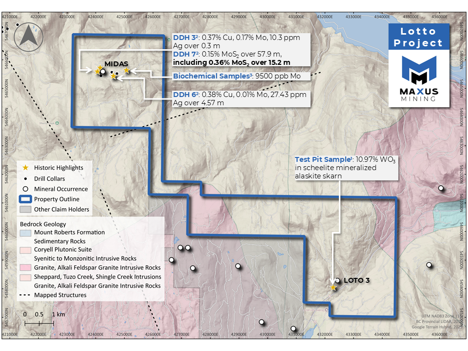
Figure 2: Lotto Project Historic Highlights Map
Qualified Person Statement
The scientific and technical information contained in this news release has been reviewed, verified, and approved by Morgan Verge, P.Geo., Technical Advisor of the Company and a “qualified person” as defined in NI 43-101 – Standards of Disclosure for Mineral Projects. Ms. Verge has examined information regarding the historical exploration at the Project, which includes a review of the historical sampling, analytical, and procedures underlying the information and opinions contained herein.
Management cautions that historical results collected and reported by operators unrelated to Maxus have not been verified nor confirmed by its Qualified Person; however, the historical results create a scientific basis for ongoing work at the Project.
References
1 ARIS 8187. Paszty, S., 1980. Assessment Report of Loto #3 Claim, Nancy Greene Lake, B.C.
2 ARIS 5197. Sellmer, H.W. and DePaoli, G.M., 1974. 1973 Geological, Geochemical, and Geophysical Assessment Report
3 ARIS 4236. Veerman, H., 1973. Geochemical Report on the Deer 27 and Deer 28 Mineral Claims Located 30 Miles West of Castlefar, B.C. at the Headwaters of Shield Creek in the Trail Creek Mining Division.
†NI 43-101 - Technical Report on the Penny Property British Columbia, NTS 82G/12 49° 55° North Latitude -115° 90° West Longitude, Derrick Strickland P.Geo., August 14, 2024.
‡Open File 1992-11, Map Number 10.
§ MILFILE No: 082FSW228 – Loto 3, 1980 Grab Sample –
https://minfile.gov.bc.ca/report.aspx?f=PDF&r=Inventory_Detail.rpt&minfilno=082FSW228
¶ Equinox Resources – November 8, 2024, ‘Ultra High Grade Naturally Occurring Antimony at Alturas Project with Assays up to 69.98% Sb’ – https://cdn-api.markitdigital.com/apiman-gateway/ASX/asx-research/1.0/file/2924-02878498-6A1236703
‖ Endurance Summarizes Antimony Results From The Reliance Gold Project, BC - Best Intervals Include 19.2% Antimony And 2.16 ppm Au Over 0.5 m In 2024 Drilling – February 24, 2025 - https://endurancegold.com/news-releases/endurance-summarizes-antimony-results-from-the-reliance-gold-project-bc-best-intervals-include-19.2-antimony-and-2.16-ppm-au/
About Maxus Mining Inc.
Maxus Mining Inc. (CSE: MAXM | FRA: R7V) is a mineral exploration company focused on locating, acquiring, and if warranted, developing economic mineral properties in premier jurisdictions. The Company is working towards progressing its diverse portfolio of exploration properties which now includes approximately 15,098 hectares of prospective terrane comprising 8,920 hectares amongst three antimony projects, 3,123 hectares encompassing the Penny Copper Project & the remaining 3,054 hectares comprising the Lotto Tungsten Project.
The Penny Copper Project covers approximately 3,123 hectares and has seen exploration activity throughout the last 100+ years with recent work including rock sampling and minor geological mapping†. The Penny Copper Project is located near the major past producing Sullivan Mine at Kimberley, British Columbia, an area that has stimulated both junior and major exploration company activities in the past year. Additionally, the Penny Copper Project saw a 2017 work program return 17 grab samples, which returned copper values up to 1,046 ppm Cu (TK17-149c), 1,808 ppm Cu (TK17-28) and 2,388 ppm Cu (TK17-12)†.
At the Quarry Antimony Project, in well-established British Columbia, Canada, one historical sample taken assayed 0.89 ppm Au, 3.8% Cu, 0.34% Zn, 42.5% Pb, and 0.65% ppm Ag and 20% Sb‡. A selected grab sample taken in 1980 at the Lotto Tungsten Project from a quartz vein with scheelite assayed 10.97% WO3§. Additionally, the Alturas and Hurley Antimony projects are strategically positioned; Alturas Project had a recent antimony discovery which saw high-grade naturally occurring antimony with assays up to 69.98% Sb¶; Hurley neighbours Endurance Gold Corp.’s Reliance Gold Project which saw antimony results from 2024 work programs include 19.2% Sb and 2.16 ppm Au over 0.5 m encountered during the 2024 drilling program‖.


Nenhum comentário